


Celebrating GIS Day 2020
Louisville, Ky (November 18, 2020) - Today we recognize GIS Day, established in 1999 to show how location intelligence through the use of geographic information systems (GIS) impacts everyone. It is now a global event that demonstrates how far GIS extends into people’s lives and provides a forum for users to showcase their unique accomplishments using GIS – in analyses, cartography, and other data visualizations.
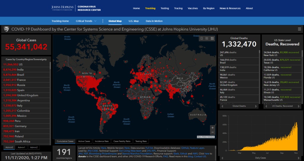
Since the very beginning of the Covid-19 pandemic, GIS has been at the forefront of people’s understanding of the dispersion of the virus and the geographic distribution of cases through the Johns Hopkins University (JHU) Covid-19 dashboard. The Center for Systems Science and Engineering at JHU developed, frequently updates, and has continued refining their dashboard to ensure transparency of information on the spread of the virus for the general public, public health officials, and other stakeholders to make data-driven and analytics-driven decisions. The frequency at which the JHU dashboard has been referenced and shown in media and government updates has further ehanced the general public’s understanding about location intelligence and how the combination of large datasets and the visualization of that data through GIS becomes a powerful tool for the “science of where.”

Connected Nation (CN) uses GIS to better understand the current broadband landscape, analyze service availability and potential expansion impacts, collect local feedback on coverage gaps, and evaluate network engineering data collections. We believe that everyone belongs in a Connected Nation and GIS is an essential tool in the analysis and display of information to direct broadband-related decision-making at the local, state, and federal levels.
This year, Connected Nation, in collaboration with GEO Jobe, upgraded and innovated several aspects of the infrastructure and software used to launch interactive mapping applications for broadband-related projects. These enhancements allow for more efficient data preparations in the launch and maintenance of applications, take advantage of hardware and software innovations that have occurred since the initial launch of CN’s interactive broadband mapping platform, and provide additional details to users of CN’s interactive maps on broadband services in their area.
To make the most of all GIS has to offer, Connected Nation is a strong advocate for professional development, continuing education, and testing strategic innovations, realizing the organizational benefits that come with training opportunities and learning innovative techniques. Connected Nation must continue to advance location intelligence methods to ensure the Digital Divide continues to decrease. Having data is one thing, but examining that data for quality, analyzing those datasets and developing maps and applications that impact policy and the public are why GIS is so essential to so many aspects of life.
At the federal level, agencies like the Federal Communications Commission (FCC) and the U.S. Department of Agriculture (USDA) are using GIS to track funding opportunities through programs like the Rural Digital Opportunity Fund (RDOF)and the ReConnect Loan and Grant Program, respectively. There are several states with broadband grant programs, such as the Minnesota Border-to-Border Broadband Development Grant Programand the Empower Rural Iowa Broadband Grant Program, which use GIS to identify unserved and underserved areas to target grants for expansion. At the local level, there are towns, counties, and regional governments using GIS to understand residential and business survey results and track vertical assets available for broadband expansion through CN’s Connected Community Engagement Program.

At Connected Nation, we will continue to innovate and strategize new ways to use GIS to allow policymakers to make the most informed decisions possible on where the Digital Divide exists, and more importantly, how to close it.
Selection of CN-developed state interactive broadband maps:
- Iowa: https://connectednation.org/iowa/interactivemap
- Michigan: https://connectednation.org/michigan/interactivemap
- Minnesota: https://connectednation.org/minnesota/interactivemap
- Texas: https://connectednation.org/texas/interactivemap
Selection of CN-developed local interactive broadband maps:
- Lewis County, Kentucky: https://connectednation.org/kentucky/lewis/interactivemap
- Noble County, Ohio: https://connectednation.org/ohio/noble/interactivemap
- Northeast Michigan Council of Governments (NEMCOG): https://connectednation.org/michigan/nemcog/assetmap
- West Michigan Regional Prosperity Alliance (WMRPA): https://connectednation.org/michigan/wmrpa/assetmap

About the Author: Ashley Hitt is the Connected Nation Vice President of GIS Services. She oversees the day-to-day operations of the GIS team. She’s responsible for developing strategies using GIS to provide data visualization solutions that impact policy, economic development, and the Digital Divide.